
Short answer: around Round Rock, the ground splits in two. To the west, most of the ground is a few inches to a few feet of soil over limestone. To the east, most of it is deep clay that swells and shrinks with the weather. Round Rock sits on the break and has some of both. Which one is under your house changes what can go wrong with a foundation, and what to check first.
Key facts
- A 2007 University of Texas study found that Round Rock "sits astride the break" between the Grand Prairie and the Black Prairie.
- In our USDA sample, very high shrink-swell clay covered none of Cedar Park's points and 92% of Manor's.
- Eckrant, the most common soil we found on the limestone side, has bedrock about 11 inches down in Williamson County.
- Houston Black, a common clay on the east side, reads very high from the surface to 80 inches down, with no rock in between.
Why the Ground Splits at Round Rock
The reason is a set of old faults called the Balcones Fault Zone. A 2007 University of Texas study mapped the bedrock under Round Rock and described the city as "bisected" by it. The faults step down to the east, which puts older Lower Cretaceous limestone on the west side next to younger rock on the east side.
Those two kinds of rock made two kinds of country. The same study describes the Black Prairie to the east as "thick black calcareous soils" over shale and chalk, once farmed for cotton, corn, oats and sorghum. To the west, the Grand Prairie has "thin, rocky soils" over limestone, with oak, cedar and grass, and was used mostly for grazing.
The University of Texas Bureau of Economic Geology describes the same line at a larger scale. The Balcones Escarpment runs from Austin through San Antonio to the Rio Grande, with the Blackland Prairies to the east and the Hill Country and Edwards Plateau to the west. And NASA's caption for an astronaut photo of central Texas says that I-35 "roughly shows the location" of this change and "generally parallels the Balcones escarpment."
So I-35 is a useful rough guide, not a fence. The break wanders, and towns that sit on it, like Round Rock, have pockets of each kind of ground.
West and east of the line
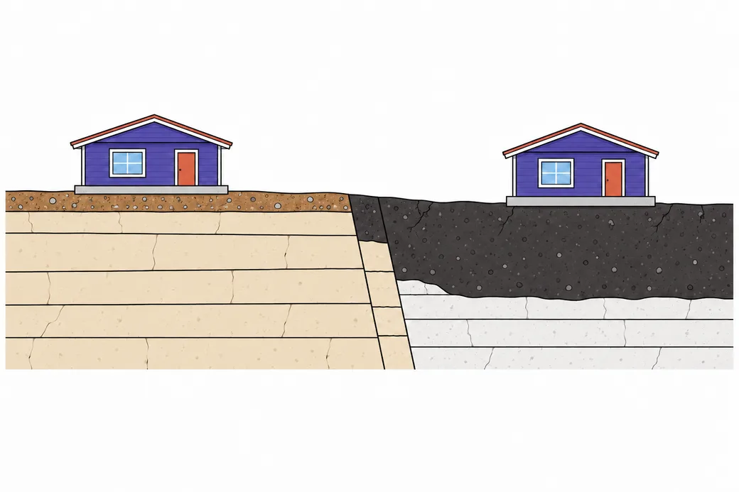
- Thin, stony soil on the west side
- Limestone beds close below the surface
- Faults where the rock steps down to the east
- Thick, dark clay soil on the east side
How Much Very High Clay Each Town Has
Soil scientists rate how much a soil swells and shrinks with a number called linear extensibility. The USDA measures it as the change in volume between a moist sample and an oven-dried one, written as a percent. Under 3 is low, 3 to 6 moderate, 6 to 9 high, and 9 or more very high. In the USDA's own words, when the rating is moderate to very high, "shrinking and swelling can damage buildings."
We checked the USDA soil survey at 25 points in and around each town and counted the share of points on very high soils. The list also shows the share on low or moderate soils, and the soil we found most often.
- Cedar Park: 0% very high, 76% low or moderate. Most common soil: Eckrant, 64%.
- Leander: 4% very high, 60% low or moderate. Eckrant, 52%.
- Liberty Hill: 4% very high, 48% low or moderate. Doss, 32%.
- Brushy Creek: 4% very high, 4% low or moderate. Georgetown soil, 48%.
- Georgetown: 8% very high, 56% low or moderate. Eckrant, 48%.
- Wells Branch: 16% very high, 36% low or moderate. Austin, 36%.
- Round Rock: 24% very high, 28% low or moderate. Austin, 20%.
- Elgin: 40% very high, none low or moderate. Crockett, 20%.
- Hutto: 56% very high, 28% low or moderate. Branyon, 44%.
- Pflugerville: 64% very high, 8% low or moderate. Houston Black, 48%.
- Taylor: 68% very high, none low or moderate. Branyon, 32%.
- Manor: 92% very high, none low or moderate. Houston Black, 40%.
The highest share anywhere in the 21 towns we studied was Granger, north of Taylor, at 96%.
Two rows deserve a second look. Brushy Creek has almost no very high soil, but it doesn't have much low soil either: its two main soils both rate high. And Elgin has no low or moderate soil at all, even though its most common soil starts out sandy. Both come down to soils that change below the surface, which we cover further down.
The Limestone Side: Thin Soil, Rock Close Below
Eckrant is the soil you'll meet most west of Round Rock. It's a stony clay that formed from weathered limestone, and it's thin. In the Williamson County survey, hard bedrock starts about 11 inches down. In the Travis County unit that pairs it with Speck soil, it starts about 8 inches down.
Other soils on this side are thin too. Doss, the most common soil in our Liberty Hill sample, sits on softer bedrock about 17 inches down. Brackett, which turned up in Leander and Liberty Hill, reads under 3 for shrink and swell and has soft rock about 14 to 16 inches down.
That doesn't mean the clay in these soils is harmless. Eckrant reads as high as 6.1 in parts of the Williamson survey. What's different is the amount: there's only a few inches of it between a slab and solid rock, so there's far less ground to swell and shrink. When a house on this side moves, the soil may still play a part, but it's worth looking hard at how water moves around the house as well.
Two Soils That Fool People
The surface can be misleading, and two soils in the area show how.
The Georgetown soil. It's the most common soil in our Brushy Creek sample, at 48%, and makes up 20% of Georgetown's. The top layer is a stony clay loam about 7 inches thick that reads only 2.5. Below it sits a layer that's about 70% clay and reads 8.5, running down to bedrock at about 35 inches. A dry, stony yard on the surface can hide a thick band of sticky clay under the slab.
Crockett, in Elgin. On the clay side, Crockett is the most common soil in our Elgin sample, at 20%. Its top layer is a fine sandy loam about 8 inches thick that reads just 1.2. Under that is clay that reads 9.0, then more clay reading 7.5 below that. A sandy flower bed can sit right on top of very active ground.
So the soil you dig up with a trowel isn't always the soil your house rests on. The survey describes the layers all the way down, and that's the part that matters for a slab.
The Clay Side: Deep Ground That Keeps Moving
Houston Black is the deep black clay you'll find across much of the prairie east of Round Rock. In the soil survey it formed from mudstone of the Upper Cretaceous age, and it reads 12.0 from the surface all the way to 80 inches down, with no rock in that depth. It's the most common soil in our Pflugerville sample (48%) and in Manor's (40%), and it makes up 16% of Round Rock's.
Branyon is the other big one. It formed from clay washed down by old streams, and it reads 9.9 in the top foot or so, then 13.0 below that to past 6 feet. It covers 44% of our Hutto sample and 32% of Taylor's. The highest readings we found in the area belong to Heiden and Ferris, at 17.0, which turned up in Round Rock, Pflugerville, Manor and Elgin.
On these soils, a slab rests on a deep bed of ground that grows when it's wet and shrinks when it dries. The weather here gives it plenty of both. The NOAA station just northeast of Round Rock averages 4.67 inches of rain in May and 2.04 inches in July, and August highs at Georgetown Lake average 96.8°F.
Depth matters for repairs on this side too. The Foundation Performance Association, a Houston group of engineers and repair contractors, warns that shallow piling "not driven sufficiently below the moisture active zone can continue to settle." Its papers were written for southeast Texas, but the point carries: on deep clay, ask how deep each pier will go and how that depth was chosen.

On the Break: Round Rock and Wells Branch
The towns right on the line are the hardest to guess. Our Round Rock sample turned up soils ranging from Eckrant with rock about 11 inches down to Houston Black with none in 80 inches. The most common was Austin silty clay, at 20%. This soil weathered out of chalk, rates 5.1, and gives way to soft bedrock roughly 29 inches below the surface.
Wells Branch is a similar mix. Austin silty clay leads at 36%, then Eckrant and Houston Black at 16% each. There's also Eddy, at 12%, a gravelly loam over chalk that reads just 1.5.
If you live in one of these towns, a neighbor's experience tells you little about your own lot. Looking it up is the only quick way to know.
How to Look Up Your Own Lot
The USDA's Web Soil Survey is free and shows the soil under any address.
1. Go to the Web Soil Survey site and choose "Start Web Soil Survey." 2. In the left panel, under "Quick Navigation," pick "Address," type yours and click "View." 3. Use the rectangle or polygon tool above the map to draw around your lot. That's your "Area of Interest." 4. Open the "Soil Map" tab. It lists the soil map units inside your area, with names like "Houston Black clay, 1 to 3 percent slopes."
Look for the first word or two of each name in this guide. Houses near Round Rock fall in the Williamson County, Travis County or Bastrop County surveys. The USDA says that some engineering uses still need a check on site, so treat the map as a strong hint, not a verdict on your house.
What Each Side Means for Your House
On the clay side, the goal is to keep the moisture under and around the slab as even as you can. The Foundation Performance Association puts it plainly: for most repair systems to work, the soil moisture "must be maintained a constant, and stormwater drainage must be directed away from the foundation." Watering rules vary by town, and our foundation watering guide covers them.
On the limestone side, start with water too, but from the other direction. With so little soil, look first at where rain and runoff go, then at any clay pockets your lot may hold.
Wherever you live, the first real step is measuring. The Texas Section of the American Society of Civil Engineers says that a single floor level survey shows how a foundation sits "at one instant," and that repeated surveys show change. A foundation inspection is how that starts.
Parts of the limestone side, including most of Georgetown and Brushy Creek, also sit over the Edwards Aquifer recharge zone. Our Edwards Aquifer guide explains what that means for work on a house.
Questions About Round Rock Soil
Is all of Round Rock on clay?
No. Only 24% of our Round Rock sample points landed on very high clay, and 28% landed on low or moderate soils. The city sits on the break, so it has some of each.
Does rock under my house mean it can't move?
No. Rock close below leaves less soil to swell and shrink, but soils like the Georgetown soil can hold a thick clay layer above the rock. Water around the house can matter too.
Which side of I-35 is my town on?
In our data, Cedar Park, Leander, Liberty Hill, Brushy Creek and Georgetown lean to the limestone side. Pflugerville, Hutto, Taylor, Manor and Elgin lean to the clay side. Round Rock and Wells Branch sit on the break. Your own lot can still differ, so look it up.
What do the soil numbers mean?
They're linear extensibility readings, a measure of how much a soil changes volume between moist and dry. Under 3 is low and 9 or more is very high.
Get a Free Foundation Inspection
If your house is showing cracks or sticking doors, we can pass your request to a foundation repair professional who works around Round Rock. They'll check the house and walk you through the results. The inspection is free, with nothing to commit to.